


MEACHAM Voting District, Marion County, Illinois
About
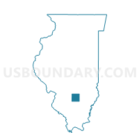
Outline

Summary
| Unique Area Identifier | 573456 |
| Name | MEACHAM Voting District |
| County | Marion County |
| State | Illinois |
| Area (square miles) | 36.66 |
| Land Area (square miles) | 36.54 |
| Water Area (square miles) | 0.12 |
| % of Land Area | 99.68 |
| % of Water Area | 0.32 |
| Latitude of the Internal Point | 38.78870800 |
| Longtitude of the Internal Point | -88.74512550 |
Maps


Graphs
Select a template below for downloading or customizing gragh for MEACHAM Voting District, Marion County, Illinois


Neighbors
Neighoring Voting District (by Name) Neighboring Voting District on the Map
- ALMA 1 Voting District, Marion County, IL
- KINMUNDY 1 Voting District, Marion County, IL
- LA CLEDE 1 Voting District, Fayette County, IL
- LARKINSBURG I Voting District, Clay County, IL
- OMEGA Voting District, Marion County, IL
- OSKALOOSA Voting District, Clay County, IL
- SONGER Voting District, Clay County, IL
Top 10 Neighboring County Subdivision (by Population) Neighboring County Subdivision on the Map
- Kinmundy township, Marion County, IL (1,186)
- La Clede township, Fayette County, IL (909)
- Alma township, Marion County, IL (836)
- Larkinsburg township, Clay County, IL (644)
- Omega township, Marion County, IL (501)
- Meacham township, Marion County, IL (375)
- Songer township, Clay County, IL (342)
- Oskaloosa township, Clay County, IL (322)
Top 10 Neighboring Place (by Population) Neighboring Place on the Map
Top 10 Neighboring Unified School District (by Population) Neighboring Unified School District on the Map
- Flora Community Unit School District 35, IL (8,201)
- South Central Community Unit School District 401, IL (4,443)
- North Clay Community Unit School District 25, IL (3,867)
Top 10 Neighboring State Legislative District Lower Chamber (by Population) Neighboring State Legislative District Lower Chamber on the Map
- State House District 102, IL (118,987)
- State House District 108, IL (102,103)
- State House District 107, IL (102,096)
Top 10 Neighboring State Legislative District Upper Chamber (by Population) Neighboring State Legislative District Upper Chamber on the Map
Top 10 Neighboring 111th Congressional District (by Population) Neighboring 111th Congressional District on the Map
Top 10 Neighboring Census Tract (by Population) Neighboring Census Tract on the Map
- Census Tract 9516, Marion County, IL (3,571)
- Census Tract 9511, Fayette County, IL (2,931)
- Census Tract 9720, Clay County, IL (2,844)
- Census Tract 9517, Marion County, IL (2,609)